Plan Princeton

DSCN8145.jpg
Vision report cover.jpg

San Mateo County, CA

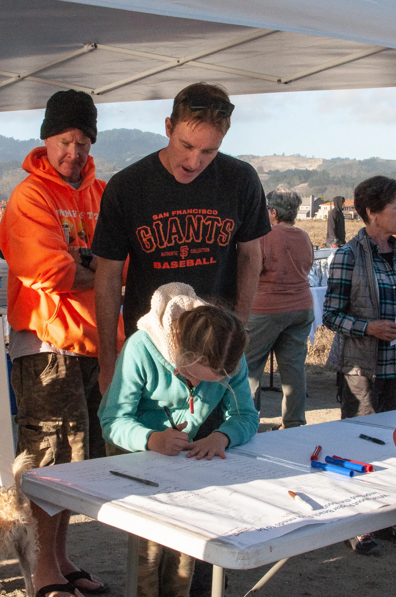
The Project. An update to the General Plan, Zoning Regulations, and Local Coastal Program for the unincorporated area of Princeton in San Mateo County. Princeton is home to one of the few working waterfronts remaining on California’s central coast that support fishing, boating, and marine-related enterprise, and has as an abundance of natural and cultural resources that make it a destination for coastal recreation. 

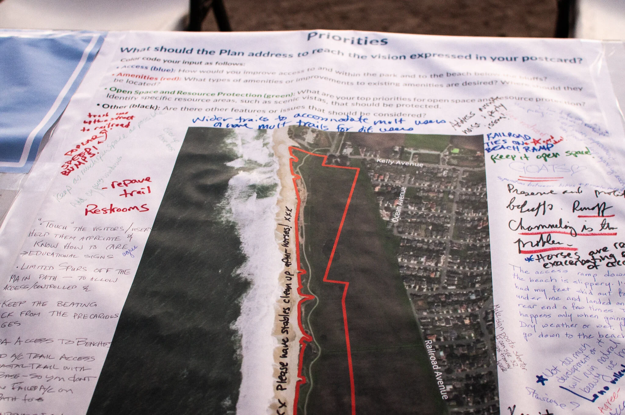
The Result. Project efforts included a detailed study of existing conditions, development of plan alternatives and a preferred plan, and draft Local Coastal Plan and Implementation Program amendments.

The Team. 
Martha Miller (while employed at D&B)


Poplar Beach Vision and Goals

DSC_0302-3.jpg
Half Moon Bay Vision and Goals Cover.jpg
Half+Moon+Bay+Vision+Input.jpg

Half Moon Bay, CA

The Project. A Vision and Goals document articulating the community’s shared vision, values, and concerns for the Poplar Beach Park area which includes a Coastal Trail segment and overlook locations, bluffs, a parking lot, beach access, and over 15 undeveloped acres of blufftop land, all of which are being threatened by erosion.

The Result. A series of outreach efforts opened channels of communication about future challenges, opportunities, and desires and helped distill the characteristics of Poplar Beach Park that community members aspire to protect, maintain, improve, change, or achieve in the future. The Vision and Goals Document articulates these community values and aspirations and provides the foundation for the Poplar Beach Gateways Plan, which will define specific programs to protect the bluffs while enhancing the park for users.

The Team. 
Martha Miller (while employed at LWC)
LWC
NCE
Gates and Associates


Honolulu TOD Zoning Framework

DSCN0645.jpg
HNL Framework cover.jpg

Honolulu, HI

The Project. A framework for citywide zoning regulations to implement individual Neighborhood TOD Plans for each of the 21 planned transit stations in Honolulu. The station areas encompass a diverse range of settings: the financial district with high-rise office buildings; low intensity suburban areas; greenfield development areas; preservation areas; areas of transition; and major points of origins and destinations. 

The Result. The challenge was to translate broad land use policies for each area into a set of regulations that addressed the unique TOD needs and opportunities for each station, implement the goals and policies of the TOD plans, and create more livable communities that take advantage of the benefits of transit. To ensure a streamlined approach, a framework was established with provisions that are common to all or most stations, those that are applied as part of station typologies (such as suburban employment stations), and those that are unique to individual stations.

The Team. 
Martha Miller (while employed at D&B)


Tahoe Basin Neighborhood and Town Center Form-based Standards

DSCN1636.jpg
Pages from Character Area Cover and Page.jpg
Tahoe character area.jpg

Placer County and South Lake Tahoe, CA

The Project. As part of the implementation program for the Regional Plan Update, Martha Miller worked with local jurisdictions throughout the Tahoe Basin to develop form-based development and design standards for Town and Neighborhood Centers to encourage environmental redevelopment. 

The Result. Character-based development and design standards were developed to create vibrant, mixed-use centers and streamline the development review and approval process. Topics addressed include pedestrian- and transit-oriented development, mixed use development, neighborhood-scale and land use compatibility, and natural resource protection. 

The Team. 
Martha Miller (while employed at D&B)


Tahoe Basin Community Plan Update

Public+Beach.jpg
Placer Bridge Cover.jpg
Placer Tahoe City Development Code Cover.jpg

Placer County, CA

The Project. The Placer County portion of the Tahoe Basin was governed by three general plans, six community plans, and 51 plan area statements; all of which were dated, reflecting conditions and trends from nearly 20 years ago. Martha Miller was the project manager for the effort to update and consolidate these plans into a consolidated policy document and set of development standards. 

The Result. The Placer County Tahoe Basin Community Plan consisted of two main parts: (1) the Policy Document which consolidated those plans into one, single, over-arching policy document that addresses land use and natural resource policy for the entire portion of Placer County within the Tahoe Basin, and (2) separate zoning/development standards and design guidelines for four sub-areas within the Plan Area boundary that reflect the unique characteristics of those communities. 

The Team. 
Martha Miller (while employed at D&B)


Mammoth Lakes Commercial District Regulations

DSCN5305.jpg
Mammoth Cover.jpg

Town of Mammoth Lakes, CA

The Project. Update of the Town of Mammoth Lakes Commercial District Regulations

The Result. Incorporation of form-based zoning standards into the Commercial District regulations to better meet the goals of the Zoning Code Update:

  • Promote Sustainability: Incorporate standards that promote sustainability of development in the Town and incorporate the goals, policies, and actions outlined in the General Plan.

  • Promote Quality and Design: Incorporate standards that improve development quality and design.

  • Improve Readability and Usability: Use charts, graphics, and illustrations to make the Code easier to read and to reorganize the material to group similar regulations together.

The Team. 
Martha Miller (while employed at D&B)


Grover Beach Parking Regulations Update

downtown+parking.jpg
car+share+pic.jpg
Parking_Perm+copy.jpg

Grover Beach, CA

The Project. An update to citywide parking regulations consistent with “best practices” and appropriate for the context of Grover Beach and the unique needs of its residents, visitors, and businesses. 

The Result. Changes to the parking regulations were designed to provide flexibility for the provision of parking while still accommodating parking demand. Changes to the parking regulations addressed usability of the standards, minimum parking requirements, and parking area design and configuration.

The Team. 
Martha Miller (while employed at LWC)


Morgan Hill Freeway-Oriented Sign Standards

morganhill.jpg
Morgan Hill_Analysis and Assessment_Cover.jpg

Morgan Hill, CA

The Project. A revision to the City of Morgan Hill’s freeway-oriented sign regulations to ensure that freeway-oriented signs serve their vital communicative function of allowing travelers, residents, and visitors alike to readily ascertain the availability and location of facilities and services that serve their needs in a manner that is consistent with the desired community character.

The Result. An analysis and assessment report which explored strategies for regulating freeway-oriented signs toward this end that served as a basis for discussion with staff and guided preparation of draft freeway-oriented sign standards and design guidelines.

The Team. 
Martha Miller (while employed at LWC)


Yuba County Development Code Update

Dutch+Flat+Trail.jpg
Development Code_Cover.jpg
Yuba County Diagnostic Report Cover.jpg

Yuba County, CA

The Project. A joint effort with staff to comprehensively update the Yuba County Development Code to effectively implement the General Plan Vision through a user-friendly, legally adequate, and effective set of regulations. 

The Result. New standards that will provide a more coherent sense of place, promote higher density residential development and commercial redevelopment in activity centers, preserve and enhance the character of rural communities, and support economic growth and agritourism. The Development Code update also combined related codes and ordinances, including the County’s zoning, subdivision, erosion control, grading/drainage, environmental compliance, and improvement ordinances, into a single, cohesive document. 

The Team. 
Martha Miller (while employed at D&B)


San Gabriel Greening the Code

parking+shade.jpg
Overview_Page_1.jpg
Overview_Page_2.jpg

San Gabriel, CA

The Project. Promote development practices that are more sustainable and environmentally friendly by integrating sustainability principles throughout the Zoning Code by identifying and removing unintended regulatory barriers and crafting amendments offering incentives, greater flexibility, and more clarity in requirements.

The Result. The City of San Gabriel first identified what “sustainability” meant to the City and its citizens, recognizing that to be successful, the project needed to reflect the needs of the community. Six key areas of sustainability were addressed through Zoning Code Amendments:

  1. Landscaping and water conservation,

  2. Open space,

  3. Parking, mobility, and connectivity,

  4. Water quality,

  5. Resource conservation, and

  6. Urban agriculture.

The Team. 
Martha Miller (while employed at D&B)

Awards
APA Los Angeles Section Award, Innovation in Green Community Planning (2014)
SCAG Sustainability Award (2014)